
Closed for the winter
Muotathal - Glarus
The Pragel Pass road between the Pragel-Bödmeren Alpine cheese dairy on the Schwyz side and Gampel on the Glarus side is now closed for the winter.
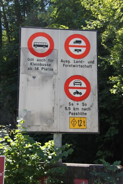
The following traffic restrictions apply to the entire Pragelpass road:
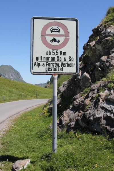
1. Motor vehicles and motorcycles are prohibited on Saturdays and Sundays, 5.5 km after the
pass summit (cantonal border SZ/GL to Richisau, approx. 2 km)
2. On public holidays that do not fall on a Saturday or Sunday, the Pragelpass is normally passable
(except winter closure)
3. Maximum weight 3.5 tons (SSV signal 2.16) except for agricultural, alpine and forestry
traffic, traffic for the construction, operation and maintenance of public and private works (incl.
electrical infrastructures), traffic for milk processing plants and military traffic;
4. Driving ban for trailers (SSV signal 2.09) except for agricultural, alpine and forestry
traffic, traffic for the construction, operation and maintenance of public and private works (incl.
electrical infrastructures), traffic for milk processing plants and military traffic;
5. Maximum weight of agricultural, alpine and forestry traffic, traffic for the construction, operation and maintenance
of public and private works (incl. electrical infrastructure) and traffic for
milk processing plants incl. trailers 32 tons (SSV signal 2.16);
6. Maximum weight of military traffic incl. trailers 12 tons.
For special permits relating to weight restrictions, please use the application form on the
online portal. https://www.bezirk-schwyz.ch/aktuelles/pragelpass/
Unchanged valid since:: 03.11.2025, 12:00
History
The wild valley in which the Starzlen River flows on the Schwyz side of the Pragel Pass was used to get to the Klön Valley on the Glarner side way back in Medieval times. The watershed at the top of the pass acted as a natural border and the area was used up to the rear Richisau to graze cattle, which was of tremendous economic importance. The urge to aquire new lands lead to tension with neighbouring areas and even had to be taken to the courts (1417/18). Disputes about border rights flared up again during the 17th century and Johann Franz Schmid, the bailiff of Uri, had to step in to mediate and it wasnt until 1680 that the borders between Glarus and Schwyz were finally determined. Even today it is still joked about the stealing of the Klön Valley.
The Pragel Pass gained historical importance with the retreat of the Russion general Alexander Suworow, who retreated from defeat in upper Italy via the Gotthard Pass, Altdorf, Chinzig Chulm and through the Muota Valley into the Klön Valley and Glarus on his way back to Russia in 1799.
Although there were no particular geological problems, the project to build a road over the Pragel Pass (1766-1908) continually fell through and a projected narrow-guage railway was also never realized (1911). It wasnt until 1939 that the Swiss Federal Government agreed to subsidise the building of a goods road. The Glarner side was built in 1940 and the Schwyz side in 1978 (with assistance from the Swiss army). The Glarner parliament forbade the use of the road on weekends, which the Swiss government also supported in 1981 and since then the road is closed for motorised traffic between Klöntal and Richisau on Saturday and Sunday. The area offers nature-lovers plenty to see with the Bödmeren forest, Silberen, Charetalp and bike riders can enjoy the car free (but not sweat free) road!
Closed time during winter: Opening / Closing Pragelpass
| Pass/Year | 2025 | 2024 | 2023 | 2022 | 2021 | 2020 | 2019 | 2018 | 2017 | 2016 | 2015 | 2014 | 2013 | 2012 | 2011 | 2010 | 2009 | 2008 | 2007 | 2006 | 2005 | 2004 | 2003 | 2002 | 2001 | 2000 | 1999 | 1998 | 1997 | 1996 | 1995 | 1994 | 1993 | 1992 |
|---|---|---|---|---|---|---|---|---|---|---|---|---|---|---|---|---|---|---|---|---|---|---|---|---|---|---|---|---|---|---|---|---|---|---|
| Pragelpass | 07.06. - 18.11. | 08.06. - 10.11. | 01.06. - 18.11. | 14.06. - 02.11. | 19.05. - 26.10. | 20.06. - 07.11. | 21.06. - 29.10. | 31.05. - 23.10. | 13.06. - 07.11. | 03.06. - 21.11. |
Technical Data
Location
Signalisation
- Fahrverbot für Gesellschaftswagen über 3.5 t Gesamtgewicht und für Kleinbusse über 14 Plätze.
- Fahrverbot für Lastwagen über 3.5 t Gesamtgewicht, ausgenommen für land- und forstwirtschaftlichen Verkehr.
- Fahrverbot für Anhänger, ausgenommen für land- und forstwirtschaftlichen Verkehr.
- Fahrverbot für Mililärfahrzeuge über 12t Gesamtgewicht
- Fahrverbot für Militärfahrzeuge über 12t Gesamtgewicht.
- Samstags und sonntags gilt ein Verbot für Motorwagen und Motorräder, ab 5.5 km nach
- Passhöhe (Kantonsgrenze SZ/GL) bis Richisau, ca. 2 km. Zuständigkeit beim Kanton Glarus.
Passes
- Closed for the winterUnchanged valid since:: 12.12.2025, 17:16-3°C12%30.4 KmWinter closure (Oct/May)
Preda - La Punt Chamues-ch
The cantonal road (mountain pass) between Berguen and Preda is a toboggan run and remains closed to motor vehicles and horse-drawn carriages during the winter from calendar week 49 until the end of the tobogganing season (usually the end of calendar week 11).
Important note: Due to persistently warm temperatures, the Preda–Bergün and Darlux toboggan runs will not be able to open on 13 December 2025. The season is now expected to open on 20 December; confirmation will follow on 18 December at 12 noon.
Winter closure from 8 December 2025 at 9 a.m.
- Open, no restrictionsUnchanged valid since:: 17.12.2025, 12:20-4°C10%37 Kmopen all year round
Pontresina - San Carlo
Winter tyres are obligatory for the whole winter period. Depending on the weather conditions, snow chains may be obligatory over a short period, or the pass may close.
- Open, no restrictionsUnchanged valid since:: 26.11.2025, 10:064°C13%13 Kmopen all year round
Lungern - Brienzwiler
Winter tyres are obligatory for the whole winter period. Depending on the weather conditions, snow chains may be obligatory over a short period, or the pass may close completely.
- Open, snow covered. Risk of slippery iceUnchanged valid since:: 10.12.2025, 14:09-3°C14.6%27 KmWinter closure (Jan /May)
Tschuggen - Susch
Between Tschuggen and Susch, expected to reopen today, December 10, 2025, from 1:00 p.m.
Davos - Susch covered in snow
Next assessment: December 10, 2025, 1:00 p.m.
Vehicle transport Flüela/Vereina Tel. 0041 81 288 37 37
- Closed for the winterUnchanged valid since:: 17.11.2025, 05:26-6°C11%29 KmWinter closure (Oct/May)
- Closed for the winterUnchanged valid since:: 29.11.2025, 02:08-2°C12.7%21.3 KmWinter closure (Oct/May)
La Motta - Country border
Important note: Between La Motta and Forcola di Livigno, on the Swiss/Italian border, the winter closure will apply from 28 November 2025 at midnight.
Traffic information for the bordering South Tyrol/Passes: www.suedtirol.com/verkehr/berg-paesse
- Closed for the winterUnchanged valid since:: 17.11.2025, 15:101°C11%32 KmWinter closure from Langis: November - April
Sarnen - Entlebuch
On the Obwalden side, the road remains open during the winter as far as Langis.
- Closed for the winterUnchanged valid since:: 17.11.2025, 11:311°C12%39 KmWinter closure from Mörlialp (Oct / May)
Giswil - Sörenberg, "Panoramastrasse"
Today, 17 November 2025, the Panoramastrasse will be closed for the winter from 5 p.m.
Important note: During the winter, the road on the Obwalden side will remain open as far as Mörlialp.
Important note: Restrictions for coaches and trucks see section Signalization.
- Closed for the winterUnchanged valid since:: 07.11.2025, 09:15-3°C9%24 KmWinter closure (Oct/May)
Hospental - Airolo
The Gotthard Pass between Hospental and Airolo can no longer be opened for safety reasons. The winter closure will apply from 8 a.m. on Friday, 7 November 2025.
Tremola (Strada turistica) Passhöhe - Airolo: 3.5 t. winter closure
- Closed for the winterUnchanged valid since:: 15.12.2025, 09:51-3°C11%24 KmWinter closure (Oct/May)
Guttannen - Gletsch
On the Bernese side, open from 14 November 2025, 2 p.m. to Guttannen.
Only ski tourers are permitted to ski the section between Guttannen and KW Handeck. Tickets for the LSB Handegg – Gerstenegg can be purchased online until 4 p.m. the evening before at www.grimselwelt.ch. For the latest avalanche and road reports, visit https://www.grimselstrom.ch/media/info/Lawinenbulletin.pdf.
- Closed for the winterUnchanged valid since:: 20.10.2025, 05:31-5°C11%44 KmWinter closure (Oct/May)
Bourg-St-Pierre - national border
Important note: On 20 October 2025 from 0800 hours, the Great St Bernard Pass will be closed for the winter.
- Closed for the winterUnchanged valid since:: 20.10.2025, 05:36-2°C15%28 KmWinter closure (Oct/May)
Meiringen - Grindelwald
The winter closure is in effect from today, 20 October 2025. The pass is expected to open in 2026: Ascension Day, 14 May 2026, with the start of bus service.
There is a general driving ban on motorized traffic between Schwarzwaldalp and Grindelwald (Hotel Wetterhorn).
- Open, no restrictionsUnchanged valid since:: 30.11.2025, 08:351°C10.1%17 Kmopen all year round
Schwyz - Oberiberg
- Open, no restrictionsUnchanged valid since:: 17.12.2025, 11:06-2°C12%16 Kmopen all year round
Bivio - Silvaplana
Winter equipment is mandatory during the winter months. Snow chains are compulsory for a limited period of time depending on the circumstances, as is any closure of the pass.
- Closed for the winterUnchanged valid since:: 31.10.2025, 03:54-4°C9%35 KmWinter closure (Oct/May)
Urigen - Urnerboden
From 31 October 2025, the Klausen Pass will be closed for the winter.
Info for car travel summer 2025:
2.30 m wide, two-axle and 18-ton vehicles do not require a permit, also applies at weekends.
From the opening of the pass in 2025 until its closure in 2025, single-decker, 2.55 m wide, two-axle and max. 18-ton touring cars (trailer ban) may travel on the Klausen Pass from Monday to Friday with a special permit. Monday, Wednesday and Friday from Unterschächen to Linthal. Tuesday and Thursday from Linthal to Unterschächen. Timing must be coordinated with Postbus routes.
Permits can be obtained from the Road Traffic Office of the Canton of Uri or the Canton of Glarus.Permits for Linthal – Unterschächen can be obtained at:
Strassenverkehrs- u. Schifffahrtsamt des Kanton Glarus,
Mühleareal17
8762 Schwanden
Tel 055 646 54 00
E-Mail: stva@gl.ch
Permits for Unterschächen - Linthal can be obtained at:
Amt für Strassen- und Schiffsverkehr
Gotthardstrasse 77a
6460 Altdorf
Tel 041 875 28 06
E-Mail: sonderbewilligungen@ur.ch
https://www.ur.ch/publikationen/6500 - Open, snow covered. Risk of slippery iceUnchanged valid since:: 08.12.2025, 15:23-1°C9%39 Kmopen all year round
Fuorns - Campra
Snow covered between Fuorns and Campra
Winter tyres are obligater for the whole winter period. Depending on the weather conditions, snow chains may be obligatory over a short period, or the pass imay close completely. See also www.lucomagno.ch
- Open, no restrictionsUnchanged valid since:: 17.12.2025, 12:220°C9%30 Kmopen all year round
Silvaplana - Casaccia
Winter tyres are obligatory for the whole winter period. Depending on the weather conditions, snow chains may be obligatory over a short period, or the pass may close Complete,
- Closed for the winterUnchanged valid since:: 27.10.2025, 10:36-3°C13%38 KmWinter closure (Oct/May)
All' Acqua - Ulrich
On the Ticino side open during the winter to All'Acqua.
- Closed for the winterUnchanged valid since:: 10.12.2025, 19:01-2°C6%23 KmWinter closure (Oct/May)
Tschamut - Andermatt
- Open, no restrictionsUnchanged valid since:: 17.12.2025, 12:190°C14.3%35 Kmopen all year round
Zernez - Tschierv
Winter tyres are obligatory for the whole winter period. Depending on the weather conditions, snow chains may be obligatory over a short period, or the pass may close completely.
Traffic information for the bordering South Tyrol/Passes: www.suedtirol.com/verkehr/berg-paesse
- Closed for the winterUnchanged valid since:: 03.11.2025, 12:00-1°C18%50 KmWinter closure (Oct/May)
Muotathal - Glarus
The Pragel Pass road between the Pragel-Bödmeren Alpine cheese dairy on the Schwyz side and Gampel on the Glarus side is now closed for the winter.
The following traffic restrictions apply to the entire Pragelpass road:
1. Motor vehicles and motorcycles are prohibited on Saturdays and Sundays, 5.5 km after the
pass summit (cantonal border SZ/GL to Richisau, approx. 2 km)
2. On public holidays that do not fall on a Saturday or Sunday, the Pragelpass is normally passable
(except winter closure)
3. Maximum weight 3.5 tons (SSV signal 2.16) except for agricultural, alpine and forestry
traffic, traffic for the construction, operation and maintenance of public and private works (incl.
electrical infrastructures), traffic for milk processing plants and military traffic;
4. Driving ban for trailers (SSV signal 2.09) except for agricultural, alpine and forestry
traffic, traffic for the construction, operation and maintenance of public and private works (incl.
electrical infrastructures), traffic for milk processing plants and military traffic;
5. Maximum weight of agricultural, alpine and forestry traffic, traffic for the construction, operation and maintenance
of public and private works (incl. electrical infrastructure) and traffic for
milk processing plants incl. trailers 32 tons (SSV signal 2.16);
6. Maximum weight of military traffic incl. trailers 12 tons.
For special permits relating to weight restrictions, please use the application form on the
online portal. https://www.bezirk-schwyz.ch/aktuelles/pragelpass/ - Closed for the winterUnchanged valid since:: 03.11.2025, 15:57-5°C9.7%17 KmWinter closure (Oct/May)
Hinterrhein - San Bernardino (Pass road, italien road).
- Open, no restrictionsUnchanged valid since:: 17.12.2025, 06:22-2°C9%67 Kmopen all year round
Brig - Gondo
Winter tyres are obligatory for the whole winter period. Depending on ithe weather conditions, snow chains may be obligatory over a short period, or the pass may close completely.
- Closed for the winterUnchanged valid since:: 01.12.2025, 11:49-7°C13%39 KmWinter closure (Oct/May)
Splügen - Country border
Closed until further notice for safety reasons.
The Splügen Pass is expected to close for the winter season from 7:00 a.m. on 1 December 2025.
- Closed for the winterUnchanged valid since:: 27.10.2025, 12:53-4°C9%46 KmWinter closure (Oct/May)
Wassen - Innertkirchen
On the Bernese side, it remains open until Obermaad.
- Closed for the winterUnchanged valid since:: 10.11.2025, 14:07-7°C12%33 KmWinter closure (Oct/May)
Sta. Maria i. M. - country border
Winter closure from Monday, 10 November 2025, 2 p.m.
Winter closure of the Stelvio Pass from Friday, 7 November 2025, 9:00 a.m.
Traffic information for neighbouring South Tirol pass: www.suedtirol.com/verkehr/berg-paesse