
Open, no restrictions
Bourg-St-Pierre - national border
Important notice: The Great St Bernard Pass will reopen on 22 June 2026 from 1100 hours.
Unchanged valid since:: 22.06.2026, 17:49
History
(Col du Gd-Saint-Bernard; Colle del Gran San Bernardo)
Artifacts found along the northern approach to the Gt. St. Bernhard Pass prove that the pass was used in the early iron ages, making it one of the oldest alpine traverses. The pass was used as a connecting axis between Gallien and the Rhine River as Julius Caesar mentions in his «De bello Gallico». The pass was widened for wagons under the rule of Emperor Claudius (54 a.d). Compared to the other passes that were also used by the Romans there were no difficult gorges and cliffs that had to be passes.
Traders, dignitaries & crusaders all used the pass during the middle ages and it was at this time that it became increasingly used by pilgrims travelling from France to Rome, as substantiated by a journel by the Archbishop Sigerich 1st of Canterbury (d. 994 a.d.).
During Roman times, a tempel revering Poeninus stood at the top of the pass and Bernhard von Menthon , Archdiakon from Aosta had a hospiz built nearby in 1050 a.d. to protect all travellers. Von Menthon was made holy and the Mt. St. Bernard Pass was named after him in the 13th century. The Earls and Dukes of Savoyen generously supported the hospiz and it was eventually taken over by the Augustinian canons. The Augustinians were known and appreciated for their hospitality over hundreds of years. In more recent times the St. Bernhard became famous for breeding St. Bernhard dogs.
The international transit trade began in the 13th century and lead to the development and economical prosperity of the villages and towns along the route. Sembrancher, Bourg-Saint-Pierre, La Cantine de Proz were known as points of goods transfer and the wares were taken over the pass on all sorts of vehicles by the locals. Road taxes and duty were collected at certain points along the way until 1808. Construction of the Mont-Cenis pass in 1803 meant direct competition for traders over the Gr. St. Bernhard, but the Gr. St. Bernhard was politically more important and brought prosperity to the canton of Valais over many hundreds of years. The pass was also of strategic military importance from the 17th century and Napoleon crossed the pass in 1800 a.d. with over 30,000 soldiers to begin battle in the Lombardy. In 1906, the border between Switzerland and Italy was finally regulated. The canon Laurent Joseph Murith («Guide du botaniste qui voyage dans le Valais», 1810) recognised the importance of the pass for explorers and researchers and financed the meteorological and geological findings of Horace Bénédict de Saussure.
The district of Valais began constructing the pass road in 1839 and the Swiss side was completed in 1893 the Italian side not until 1905. The idea of a tunnel under the Col de Menouve, which could be open summer and winter, was already touted in the 19th century and the Valais cantonal government granted permission to build such a tunnel in 1938. Violent opposition from Swiss federal authorities, Simplon supporters and the SBB delayed construction begin until 1958. Europes first underground alpine road tunnel was opened on 13 April 1964. Passenger and goods transport increased continually. The opening of the Gotthard Tunnel reduced the importance of the Gr. St. Bernhard. The best known «face» of the Gr. St. Bernhard still remains that of «Barry» - the St. Bernhard dog with the schnapps bottle tied around his neck.
Closed time during winter: Opening / Closing Grosser Sankt Bernhard
| Pass/Year | 2026 | 2025 | 2024 | 2023 | 2022 | 2021 | 2020 | 2019 | 2018 | 2017 | 2016 | 2015 | 2014 | 2013 | 2012 | 2011 | 2010 | 2009 | 2008 | 2007 | 2006 | 2005 | 2004 | 2003 | 2002 | 2001 | 2000 | 1999 | 1998 | 1997 | 1996 | 1995 | 1994 | 1993 | 1992 |
|---|---|---|---|---|---|---|---|---|---|---|---|---|---|---|---|---|---|---|---|---|---|---|---|---|---|---|---|---|---|---|---|---|---|---|---|
| Grosser Sankt Bernhard | 06.06. - 20.10. | 13.06. - 14.10. | 01.06. - 16.10. | 31.05. - 17.10. | 04.06. - 18.10. | 29.05. - 12.10. | 03.06. - 14.10. | 05.06. - 15.10. | 30.05. - 04.11. | 03.06. - 17.10. | 05.06. - 19.10. |
Accommodation and activities

Technical Data
Location
Signalisation
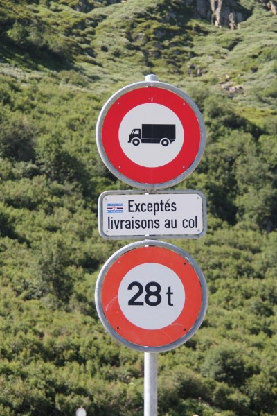
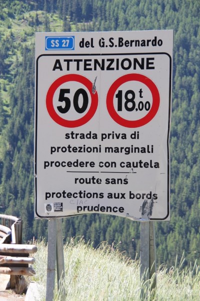
Bourg St Bernard - Landesgrenze
- Höchstgewicht 28 t
- Verbot für schwere Motorfahrzeuge. Ausgenommen sind Lieferungen zum Hospiz
Passes
- Open, with restrictionsUnchanged valid since:: 29.06.2026, 20:5616°C12%30.4 KmWinter closure (Oct/May)
Preda - La Punt Chamues-ch
Important notice:
Due to roadworks, the Albulastrasse, between Crap Alv and Albula Hospiz, will be closed to all traffic on the following nights, from 7.00 pm to 5.00 am.
There is no alternative route. Monday, 29 June 2026 – Thursday, 2 July 2026; Monday, 6 July 2026 – Wednesday, 8 July 2026;
Tuesday, 21 July 2026 – Wednesday, 22 July 2026
The closures are subject to weather conditions. The alternative dates:
Thursday, 2 July 2026 – Friday, 3 July 2026; Wednesday, 8 July 2026 – Friday, 10 July 2026;
Wednesday, 22 July 2026 – Thursday, 23 July 2026
- Open, no restrictionsUnchanged valid since:: 06.07.2026, 08:3421°C10%37 Kmopen all year round
Pontresina - San Carlo
Notice: Traffic disruption between Baraccone and the Bernina Pass / Cattle Drive
Saturday, July 11, 2026, between 7:15 a.m. and 7:45 a.m.
Winter tyres are obligatory for the whole winter period. Depending on the weather conditions, snow chains may be obligatory over a short period, or the pass may close. - Open, no restrictionsUnchanged valid since:: 29.03.2026, 17:5626°C13%13 Kmopen all year round
Lungern - Brienzwiler
Winter tyres are obligatory for the whole winter period. Depending on the weather conditions, snow chains may be obligatory over a short period, or the pass may close completely.
- Open, no restrictionsUnchanged valid since:: 12.06.2026, 08:0514°C14.6%27 KmWinter closure (Jan /May)
- Open, no restrictionsUnchanged valid since:: 23.06.2026, 07:3316°C11%29 KmWinter closure (Oct/May)
Realp - Oberwald
- Open, no restrictionsUnchanged valid since:: 10.06.2026, 17:5822°C12.7%21.3 KmWinter closure (Oct/May)
La Motta - Country border
Traffic information for the bordering South Tyrol/Passes: www.suedtirol.com/verkehr/berg-paesse
- Open, no restrictionsUnchanged valid since:: 29.05.2026, 17:0621°C11%32 KmWinter closure from Langis: November - April
Sarnen - Entlebuch
The urgent structural work has been completed. The road is now open again.
On the Obwalden side, the road remains open during the winter as far as Langis.
- Open, no restrictionsUnchanged valid since:: 13.05.2026, 14:4222°C12%39 KmWinter closure from Mörlialp (Oct / May)
Giswil - Sörenberg, "Panoramastrasse"
Important notice: On 13 May 2026, Panoramastrasse will reopen to traffic from 3 pm.
Important note: During the winter, the road on the Obwalden side will remain open as far as Mörlialp.
Important note: Restrictions for coaches and trucks see section Signalization.
- Open, no restrictionsUnchanged valid since:: 21.05.2026, 19:1518°C9%24 KmWinter closure (Oct/May)
Hospental - Airolo
Tremola (Strada turistica) Passhöhe - Airolo: 3.5 t. The Tremola will reopen on Friday 22 May 2026 from 08:00
- Open, no restrictionsUnchanged valid since:: 21.06.2026, 10:5118°C11%24 KmWinter closure (Oct/May)
Guttannen - Gletsch
Important notice: The road between Oberwald and Gletsch is open again. The accident site has been cleared.
- Open, no restrictionsUnchanged valid since:: 22.06.2026, 17:4920°C11%44 KmWinter closure (Oct/May)
Bourg-St-Pierre - national border
Important notice: The Great St Bernard Pass will reopen on 22 June 2026 from 1100 hours.
- Open, no restrictionsUnchanged valid since:: 15.05.2026, 06:3119°C15%28 KmWinter closure (Oct/May)
Meiringen - Grindelwald
Pass opening 2026: Ascension Day, 14 May 2026, with the start of bus services.
There is a general driving ban on motorized traffic between Schwarzwaldalp and Grindelwald (Hotel Wetterhorn).
- Open, no restrictionsUnchanged valid since:: 02.04.2026, 13:5421°C10.1%17 Kmopen all year round
Schwyz - Oberiberg
- Open, no restrictionsUnchanged valid since:: 10.06.2026, 21:5417°C12%16 Kmopen all year round
Bivio - Silvaplana
Winter equipment is mandatory during the winter months. Snow chains are compulsory for a limited period of time depending on the circumstances, as is any closure of the pas
- Open, no restrictionsUnchanged valid since:: 01.07.2026, 16:1521°C9%35 KmWinter closure (Oct/May)
Urigen - Urnerboden
Notice regarding roadworks: To ensure the safety of the road infrastructure, a retaining wall on the valley side is being renovated in the Schlierenegg area (located between the pass summit and Urnerboden). The works are expected to last until October 2026. Traffic in the construction zone is being controlled by traffic lights. There may be short delays.
Info for car travel summer 2026:
2.30 m wide, two-axle and 18-ton vehicles do not require a permit, also applies at weekends. Timing must be coordinated with Postbus routes.
From the opening of the pass in 2026 until its closure in 2026, single-decker, 2.55 m wide, two-axle and max. 18-ton touring cars (trailer ban) may travel on the Klausen Pass from Monday to Friday with a special permit. Monday, Wednesday and Friday from Unterschächen to Linthal. Tuesday and Thursday from Linthal to Unterschächen. Timing must be coordinated with Postbus routes.
Permits can be obtained from the Road Traffic Office of the Canton of Uri or the Canton of Glarus.Permits for Linthal – Unterschächen can be obtained at:
Strassenverkehrs- u. Schifffahrtsamt des Kanton Glarus,
Mühleareal17
8762 Schwanden
Tel 055 646 54 00
E-Mail: stva@gl.ch
Permits for Unterschächen - Linthal can be obtained at:
Amt für Strassen- und Schiffsverkehr
Gotthardstrasse 77a
6460 Altdorf
Tel 041 875 28 06
E-Mail: sonderbewilligungen@ur.ch
https://www.ur.ch/publikationen/6500 - Open, no restrictionsUnchanged valid since:: 29.06.2026, 21:2321°C9%39 Kmopen all year round
Fuorns - Campra
Road closure between Passhöhe and Campra lifted
Winter tyres are obligater for the whole winter period. Depending on the weather conditions, snow chains may be obligatory over a short period, or the pass imay close completely. See also www.lucomagno.ch
- Open, with restrictionsUnchanged valid since:: 24.06.2026, 11:3521°C9%30 Kmopen all year round
Silvaplana - Casaccia
Important notice: Road closure between Maloja and Casaccia. Wednesday 1 July 2026 between 0530 and 0730 / Cattle drive
Winter tyres are obligatory for the whole winter period. Depending on the weather conditions, snow chains may be obligatory over a short period, or the pass may close Complete,
- Open, no restrictionsUnchanged valid since:: 05.06.2026, 06:5816°C13%38 KmWinter closure (Oct/May)
All' Acqua - Ulrich
On the Ticino side open during the winter to All'Acqua.
- Open, no restrictionsUnchanged valid since:: 26.06.2026, 21:1720°C6%23 KmWinter closure (Oct/May)
Tschamut - Andermatt
- Open, no restrictionsUnchanged valid since:: 01.07.2026, 07:5814°C14.3%35 Kmopen all year round
Zernez - Tschierv
Important notice: Due to a sporting event, the Munt La Schera Tunnel (between Punt la Drossa and Punt dal Gall) will be closed on Saturday 4 July 2026 from 0700 to 0830.
Winter tyres are obligatory for the whole winter period. Depending on the weather conditions, snow chains may be obligatory over a short period, or the pass may close completely.
Traffic information for the bordering South Tyrol/Passes: www.suedtirol.com/verkehr/berg-paesse
- Open, no restrictionsUnchanged valid since:: 02.07.2026, 15:0920°C18%50 KmWinter closure (Oct/May)
Muotathal - Glarus
The following traffic restrictions apply to the entire Pragelpass road:
1. Motor vehicles and motorcycles are prohibited on Saturdays and Sundays, 5.5 km after the
pass summit (cantonal border SZ/GL to Richisau, approx. 2 km)
2. On public holidays that do not fall on a Saturday or Sunday, the Pragelpass is normally passable
(except winter closure)
3. Maximum weight 3.5 tons (SSV signal 2.16) except for agricultural, alpine and forestry
traffic, traffic for the construction, operation and maintenance of public and private works (incl.
electrical infrastructures), traffic for milk processing plants and military traffic;
4. Driving ban for trailers (SSV signal 2.09) except for agricultural, alpine and forestry
traffic, traffic for the construction, operation and maintenance of public and private works (incl.
electrical infrastructures), traffic for milk processing plants and military traffic;
5. Maximum weight of agricultural, alpine and forestry traffic, traffic for the construction, operation and maintenance
of public and private works (incl. electrical infrastructure) and traffic for
milk processing plants incl. trailers 32 tons (SSV signal 2.16);
6. Maximum weight of military traffic incl. trailers 12 tons.
For special permits relating to weight restrictions, please use the application form on the
online portal. https://www.bezirk-schwyz.ch/aktuelles/pragelpass/ - Open, no restrictionsUnchanged valid since:: 17.05.2026, 12:1923°C9.7%17 KmWinter closure (Oct/May)
Hinterrhein - San Bernardino (Pass road, italien road).
- Open, no restrictionsUnchanged valid since:: 06.05.2026, 16:2721°C9%67 Kmopen all year round
Brig - Gondo
Winter tyres are obligatory for the whole winter period. Depending on ithe weather conditions, snow chains may be obligatory over a short period, or the pass may close completely.
- Open, no restrictionsUnchanged valid since:: 29.06.2026, 22:2315°C13%39 KmWinter closure (Oct/May)
Splügen - Country border
- Open, no restrictionsUnchanged valid since:: 02.07.2026, 08:1317°C9%46 KmWinter closure (Oct/May)
Wassen - Innertkirchen
Block lifted.
- Open, no restrictionsUnchanged valid since:: 08.07.2026, 08:1213°C12%33 KmWinter closure (Oct/May)
Sta. Maria i. M. - country border
Important notice: Due to a sporting event, the road between Bormio and Passo dello Stelvio (Stilfserjoch) will be closed on Sunday 12 July 2026 between 0800 and 1400.
The Umbrail Pass is open to traffic as normal up to the summitTraffic information for neighbouring South Tirol pass: www.suedtirol.com/verkehr/berg-paesse